|
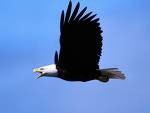
| A bald eagle in flight. |
|
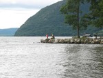
| Fishing at Plum Point on Cornwall Bay. |
|
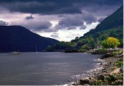
| Mary Hall took this photo of Cornwall Bay this spring. |
October 13, 2008
Tom Lake is a naturalist working with the Hudson River Estuary Program, which frequently conducts nature programs at Plum Point in New Windsor. He recently made this observation of the abundant wildlife that can be found along the shores of Cornwall Bay:
“Sloop Hill is perched on the shoulder of Cornwall Bay just upstream of Moodna Creek. The forested ridge is at least a quarter-mile long and is dominated by oaks, tulip trees, sycamores, and cottonwoods.
At low tide today (September 24) the bay was empty and the skeletal deadfalls of old trees were exposed. There was an interesting collection of raptors, three of them, perched in the trees along Sloop Hill: an osprey, a red-tailed hawk, and an adult bald eagle.
Out in the bay the dinner table had been set for the osprey and eagle and the red-tail might, sooner or later, spot the red squirrel (an uncommon sighting in itself) that I had spotted scampering along the beach a hundred feet below its perch.
It was 399 years ago today that Henry Hudson and the Half Moon passed here on their way down river. Eagles, ospreys and hawks were watching then as well.”
Learn more about the what wildlife people are seeing on the Hudson River in the Hudson River Almanac, published online by the New York State Department of Environmental Conservation (DEC).
Comments:
|
It ought to be noted that the feature discussed in this article, Sloop Hill, is not the feature indicated on the US Geological Survey map for the Cornwall Quadrangle. Sloop Hill was the high point immediately south of the head of navigation of Moodna Creek, and was scalped by the construction of Rte 9W. It has since been shortened even more, so that "Sloop Hill Road" seems to be a misnomer, but there WAS a hill there. The feature noted in the article, above and west of Plum Point, is Couwanham's Hill. It is, however, good to see that Plum Point seems correctly to be identified by Mr. Lake.
posted by Mel Johnson on 10/13/08 at 7:17 PM
|
Add a Comment:
Please signup or login to add a comment.
|
 |
|