 |
| April 26, 2024 |
Welcome! Click here to Login
|
 |
|
|

|
|
|
Click to visit the
Official Town Site
|
|
|
|
|
|
Photos: Remnants of the O & W Railroad, Part II
|
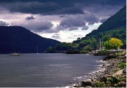
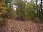
| The beginning of my trip with the railroad bed on the right. |
|
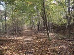
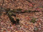
| Remnants of railroad ties in the rail bed |
|
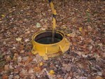
| Old sewer system in Firthcliff. |
|
| The right fork of the railroad bed goes to Firthcliff carpet mill, the left to Mill Street. |
|
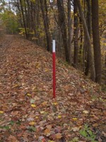
| Utility markers along the way (gas lines). |
|
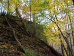
| The start of the trestle near Mill Street. |
|
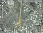
| Google satellite view of O&W tracks remnants. |
October 09, 2008
The O & W Railroad, built in the 1870s, opened up the Catskills to people from New York City and the Hudson Valley, running a line that ran from Cornwall Landing to Lake Oneida and north to Lake Ontario. The line flourished for decades, then went out of business in 1957, more than 50 years ago. Since then, hikers have praised the natural beauty they find along the train bed.
Cornwall-on-Hudson scenic photographer Phill Hopp knows his way along the old train bed and sent along these photos he took of the crumbling track ruins. Last year, Hopp sent photos of the O&W train tracks closer to Cornwall Landing. You may view those photos here.
Here's what Phil has to say about where he took these photos:
"I started about 1/2-mile off Forge Hill Road, parallel to Route 9W, on the NW side. I followed the old railroad bed from there into Firthcliff and Mill Street (in Cornwall).
The track split near Firthcliff, with one bed going into the Firthcliff Carpet Mill and the other to the left and on into Mill street. Directly across from the newer homes on Mill Street there used to be a very long trestle, whose remnants are still there. The remnants are concrete bases and footings, with some steel still attached.
This trestle crossed Moodna Creek and Rt. 32, just up from Orrs Mills Road and the old flour mill that used to be at the base of Orrs Mills Rd. (By the way, this old flour mill was in service from the Revolutionary war until WWI. There is a plaque on a rock stating this, hence the name Orrs Mill Road.
As you cross Rt. 32, the remnant of the other trestle base can be seen. The railroad crossed here and followed along parallel with Orrs Mills Road until it crossed the New York State Thruway, where it bore off to the north and west, toward Route 94.
Another rail line, the Erie Railroad, sent a line south and west, following parallel with Pleasant Hill Road until it crossed the Moodna and Woodbury Creeks, passed the site of the Black Rock Fish and Game Club, and on into Ketchum's Store In Mountainville ( Mountainville used to be called Ketchumville).
CLICK HERE FOR MORE PART II PHOTOS OF THE O&W RAILROAD IN CORNWALL.
Ed: Reader Frank Ostrander sent in several useful links to historical information about the O&W railroad that readers may enjoy. Here's what he sent:
"Inspired by reading your article about Phil Hopp's photos, I stumbled upon a 1966 article from Sports Illustrated magazine about plans to turn the O&W right-of-way into a 272 mile long hiking trail. Sadly, that never materialized. Anyway, here's a link: Sports Illustrated article
There's a web site devoted to Existing RR Stations: http://ny.existingstations.com/
Here's the Orange County page: http://ny.existingstations.com/counties/Orange.html
Note that the West Cornwall (Enderlin) station, also on the Erie Newburgh Shortcut, still stands and is fairly well preserved. It's at the end of Station Rd. off of Orrs Mills Road.
Here's a Google Satellite image (see above left) that clearly shows the NYO&W (crossing under Beakes Road and the Thruway and then heading northwest), the Erie Shortcut (parallel to the Thruway), and another abandoned Erie Branch (crossing the O&W just south of the High School and heading West toward Salisbury Mills).
CLICK ON ANY PHOTO FOR A LARGER VIEW.
Comments:
No comments have been posted.
Add a Comment:
Please signup or login to add a comment.
|
 |
|
|
|